Guide
to the
Pinnell Mountain Trail
Where is Pinnell Mountain???
The correct answer is that "Pinnell Mountain is a 4934' peak (official government measurement) located on Planet Earth at coordinates N 65° 30.637', W 145° 36.891' (my measurement).
Despite evidence on the world wide web, Pinnell Mountain is not in Arkansas and while it has views of the midnight sun, Pinnell Mountain is not near Hyder Alaska which has no view of the midnight sun being on the border with British Colombia in southeastern Alaska. Furthermore the Pinnell Mountain Trail is 27.3 miles long, not 22 miles, nor 13.6 miles. Having disposed of as many web errors as I could digest in one sitting, we now turn to official errors.
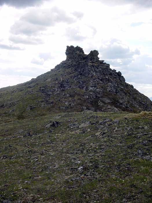
Once upon a time, many years ago at a time when communists roamed the earth and people were busy constructing bomb shelters it was decided to name a mountain after Robert Pinnell, a government employee, who died in a fall while climbing nearby Porcupine Dome. An obvious choice was Porcupine Dome however this presented a bureaucratic problem and besides who wanted to deal with a bunch of enraged porcupines and people who despise name changes. Therefore, a higher peak was chosen west of Porcupine Dome.
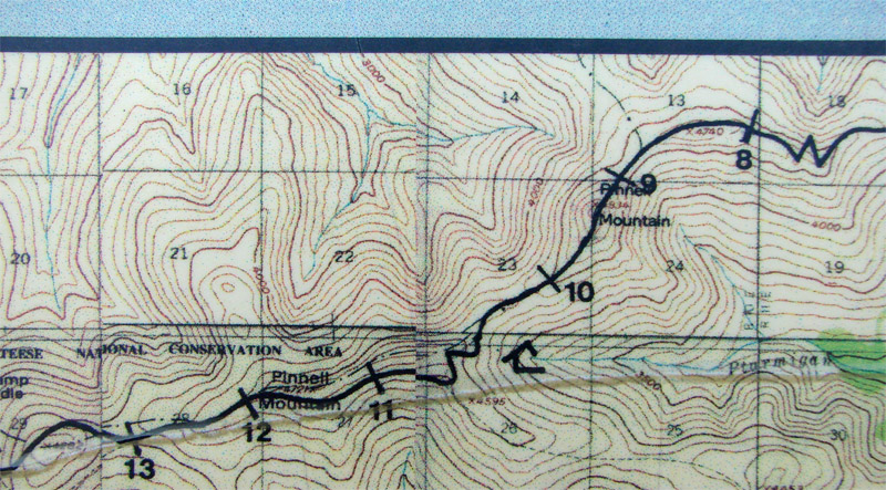
Unfortunately when it came time to label the peak on the map, the label was placed next to a lower (Elev. 4721') peak at N 65° 29.636', W 145° 40.457' (again my measurement). If we look at the Porcupine Dome area on the Circle Quadrangle map from the Alaska Topographic Series we see that the peak (see arrow) which should be labeled as Pinnell Mountain is not nearly as eye-catching as the labeled peak due to this lower peak having an elevation listed.
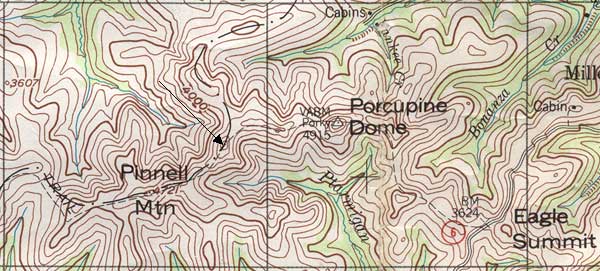
To further confuse the situation, when it came time to label the 15 minute quadrangle maps, the label was placed on the 4721' peak on the Circle B-4 quadrangle map. In a later issue of the maps the label was placed on the 4934' peak in the Circle C-4 quadrangle map and was removed from the B-4 quadrangle map.
The bible for "what is where in Alaska" is the Geological Survey Professional Paper 567, "Dictionary of Alaska Place Names" by Donald J. Orth, published in 1967. Once published, errors don't usually perish. Unfortunately the shorter peak made it into this publication as seen below.
So why not simply go along with Orth and most of the maps. Alas the lower "peak" is not exactly a peak but rather a bump on the end of a long ridge.
Hence the transfer of the Pinnell Mountain label from Circle B-4 to Circle B-3.
So now the confusion is over. Right! Well not exactly. Both BLM and the Fairbanks Alaska Public Lands Information Center brochures have maps with Pinnell Mountain correctly labeled. However, the BLM Pinnell Mountain National Recreration Trail brochure tells us that "Pinnell Mountain, the highest point along the trail at 4721 feet ... Apparently someone preparing the text on one side of the brochure used the description in Orth rather than the information on the other side of the brochure. More fun awaits those using the National Geographic Seamless USGS Topographic Maps on CD-ROM which has used maps of different vintages and therefore has two Pinnell Mountains approximately three miles apart. Also there is the "Alaska Atlas and Gazetteer" from DeLorm Mapping which has the incorrect peak labeled as Pinell Mountain and then shows the North Fork trail shelter in the incorrect place as well.
Finally, below is a portion of the sign at Eagle Summit showing two Pinnell Mountains